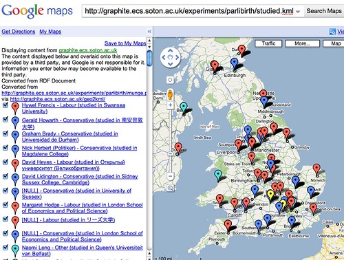
Last night Tony Hirst was trying to work out the birth-places and universities of the current UK MPs.
Here’s what I managed to produce while hacking with a glass of wine & TV on:

I did some seat of the pants data munging so I thought it’s worth explaining the process I used:
List of MPs
For the graph of MP’s birth-decade I did earlier in the year, I used a dbpedia relationship which gave me a nice little subject ‘member of 2005 UK Parliament’. This time around I can’t find anything so easy for the 2010 Parliament.
Solution, I used http://en.wikipedia.org/wiki/MPs_elected_in_the_UK_general_election,_2010 and a dirty little script…
my @tables = split(/<table/, join(”,<>));foreach my $tr ( split( /<tr/, $tables[3] ) ) { my @td = split( /<td/, $tr ); if( $td[5] =~ m!”/wiki/([^”]+)”! ) { print “$1\n”; }
} (sorry for the godawful formatting, having hassles pasting code into wordpress since our upgrade.)
This then got munged in a text editor to create a .ttl file (much nicer way to express RDF than XML, esp. when doing hacky scripts)
This gives me this: data, [Browse].
Later I did something almost identical to produce a file adding affiliations as a party label and as an icon red/blue/yellow/other.
This gives me this: data, [Browse].
In retrospect I could have done this in one go, but it was late. Note the raw data of this file is just of the N-Triples format which is really easy to create and easy to import as RDF.
Making the Map Data
I then wrote a quick PHP script using my own Graphite Library to turn this data into geocoded RDF. eg. each resource as rdfs:label, geo:lat, geo:long and also an icon predicate I made up for the day.
View code: http://graphite.ecs.soton.ac.uk/experiments/parlibirth/mpmunge.php
View output: http://graphite.ecs.soton.ac.uk/experiments/parlibirth/mpmunge.php
As it’s a one-shot, I’ve just hard wired the relationship as “http://dbpedia.org/ontology/birthPlace” and then I just grab the results using curl. eg.
curl http://graphite.ecs.soton.ac.uk/experiments/parlibirth/mpmunge.php > born.ttl
…and then modify to “almaMater” and repeat.
- http://graphite.ecs.soton.ac.uk/experiments/parlibirth/born.ttl
- http://graphite.ecs.soton.ac.uk/experiments/parlibirth/studied.ttl
Making Maps
This gives me files which can be loaded into my GeoRDF2KML tool. This forwards directly to Google Maps as that will accept the URL of a KML file as an input parameter.
Full disclosure; I added a dirty late night hack to geo2kml to accept my icon predicate to allow you to change what icon appears so I can get the by-party-colour-codes. If anyone has a ‘proper’ predicate to relate a geolocation to a map icon, let me know and I’ll support it.
To make things simple, I used ‘curl’ again to save the KML files to the same website.
Final Maps:
Note that the data is patchy. It only shows MPs with a geocoded birthplace/university listed on dbpedia.


0 Responses
Stay in touch with the conversation, subscribe to the RSS feed for comments on this post.