Currently browsing tag

acrg, Page 10

How to fix incorrectly aligned RTI images

Often, when capturing a RTI data set, especially when using a cable, the images captured can be out of place, resulting in an incomplete data set. The following is a how to guide to fix this problem using Photoshop. 
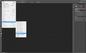
The first step is to load all of the files into Photoshop using the correct tool. This is done by clicking the file tab, then Scripts and then “Load files into Stack”. Continue reading →

Geophysics at Karnak – Intensive GPR survey and the beginning of the end of the survey

The latest work on the THaWS project has been marked by the intensity of survey profiles and survey areas covered, and  the fact that the team have been working almost exclusively in and around Karnak temple. The transition of the GPS survey from the West to the East Bank went smoothly, as reported in the last post. We established a base station on the roof of Chicago House on the West Bank, with the very kind permission of the staff. Continue reading →

Kom El Hetan, Thutmoses III and Karnak – from the West to the East Bank

A few days of work have happened since the last blog, and plenty has happened since the weekend. The team woke up on Monday to find that it had been raining all night in Luxor, and it continued until the middle of the morning. So much so in fact that a huge pool of water developed next to the flat entrance. The inadequate drainage meant that around 3pm a van turned up and pumped the water away. Continue reading →

Day Two at Kom el Hetan

More area to survey today behind the Colossi of Memnon on the West Bank. We started the day one person down, as Dom’s insides are still rumbling, possibly due to the Egyptian cuisine.  He stayed in to do some office work, and the rest headed out to cross the Nile. We continued the GPR survey behind the Colossi of Memnon, and ran two ERT profiles in front of the same. In addition Sarah’s search for survey stations from previous years continued with the GPS rover. Continue reading →

THaWS Project – Start of the week survey at Kom el Hetan

The start of another busy week in Thebes and the team headed back to the West Bank to commence GPR and ERT survey in the vicinity of Kom El Hetan and the Colossi of Memnon. The bus stopped however for a short visit to the impressive brickworks on the east bank to the south of Luxor. A massive chimney and a series of arched entrances leading to the kilns mark the site on the banks of the Nile. Continue reading →

Grab the CAD with GrabCAD

Today I had very interesting meeting with chief engineer from GrabCAD. As they say on their website GrabCAD is a community founded by mechanical engineers. It is also a place for engineers to share their talent, expand knowledge, find a dream project and work with tools and features that make life better. We were discussing how this engineering tool, which enables you to share and collaboratively work with your 3D models, could be used in cultural heritage and archaeology. Continue reading →

sotonDH small grants: ‘A Connected Island?’: measuring academic influence

This second blog post about the Connect Island project, funded by a sotonDH small award, discusses the relative influence of Central European Palaeolithic researchers using the H-index measure. Figure 1: H-index scores of Central European Palaeolithic researchers (left) versus Iron Age (right) researchers. It has been claimed that Central European archaeologists specializing in Stone Age studies are quite well-known in the West compared to their colleagues leading research in later epochs. Continue reading →

Acoustic properties of Moche sites in the Jequetepeque valley, Peru (Dianne Scullin, Columbia)

Earlier this month, I attended the South American Archaeology Seminar, hosted bi-annually at UCL by Dr Bill Sillar. These sessions are an outlet for a broad variety of interests and terrific original research stemming from archaeologists working South America and the Caribbean, yet the overlap with archaeological computing is a surprisingly rare occurrence. Continue reading →

RTI & the Late Bronze Age stela of Mirasiviene

This Late Bronze Age (LBA) stela was found many years ago in a country-estate located in the Guadalquivir Valley (South Spain). Last September David Wheatley (University of Southampton), Leonardo García Sanjuán (University of Seville) and I have conducted fieldwork on the site where it was found (see also: previous post). We have also applied advanced techniques to obtain a detailed recording of the stela: RTI and laser scanning. Continue reading →