During the initial designing phases for the TravelSafe app we came up with the idea of a ‘Safest Route Generator’ as a prominent feature which no other safety apps on the market offer. The idea is for a map routing algorithm to take into account other data sets, such as crime statistics of an area, before generating a suggested route path from A to B. It would then use social networking to generate it’s own data using a user’s experience to rate the routes, thus generating a ‘safety’ rating that could be incorporated into the algorithm. However, for this feature to work comprehensively there are a number of considerations to take into account which this blog post will explain and evaluate. These include a literature review to understand the mapping market in greater detail, what limitations exist for mapping algorithms and networks, existing examples of route generators, how routes may be ranked, a proposed methodology for our Safest Route Generator and finally a discussion of the network and predicted outcome of the feature based on all of the above.
1.0 Map Routing Algorithms
During the ‘Information Age’ the functionality of mapping Applications (apps) has increased dramatically (Pascalau, 2011). The range of uses that computing is applicable to is largely responsible for this, which extends to logistics planning, traffic simulations and shortest-path queries (Pascalau, 2011). Route generators were originally based on adapted simplified algorithms, such as Dijkstra’s algorithm in 1956, which finds the shortest path between two nodes in a graph (Jasika et al., 2012). As technology evolved along with our understanding of the more complex aspects that may shape a route, such as traffic or vehicle type, so did the algorithms used to calculate them (Jasika et al., 2012).
Modern algorithms take into account huge volumes of data and metadata (Sander and Schultes, 2007). Unlike Dijkstra’s basic algorithm they aren’t looking simply for the shortest route anymore – they’re looking for the best route available (Sanders and Schultes, 2007). This allows for companies and individuals to tailor their mapping software and route generators to a specific use or cause by placing a higher priority on the influencing aspects that they consider essential to their own project (Quercia et al., 2014). As mapping is a vast industry there is a multitude of factors that may potentially be considered for any one project, these include:
- Length of route
- Geographical features
- Understanding what the target audience needs from the map
- Ease of use from the platform
- Type and quality of supporting datasets
- Form and complexity of route instructions
- Type of vehicle/on foot options and impacts
- Off-limits or privately owned land taken into consideration
In addition to routing, networks play a key role in the generation of map routes in mapping apps (Bishop et al., 1998). Networks are the connections of nodes and links that form graphs, and similarly they have developed over-time to incorporate the evolution of algorithms, consumer need and technology (Bishop et al., 1998). Nodes specify which links connect to them and vice versa, which then creates a graph to traverse (Bishop et al., 1998). Particularly in the mapping industry, geographic Face Routing is commonly used, shown in figure 1 below.
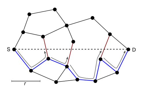
Figure 1.
In this example, a message is routed along the interior of the faces of the graph, with face changes at the edges crossing the S-D line (shortest distance). The final path is shown in blue, illustrating how the network deciphers the shortest route based on that particular network (Finn, 1987).
2.0 Problems and Limitations
Despite a number of general and more specific routing methods currently employed in the mapping market, it is important to note that the dominating players, such Tomtom, do not publish the intricacies of their software or methodologies (reference). As such a majority of companies who wish to produce a similar product or app are forced into three main categories: They can either buy the research and information from an existing company or product, invest large amounts of money and man-power into researching and building a network for themselves (which holds no guarantee of being better than the existing ones), or utilise free open data and open access software such as OpenStreetMap (reference). In addition to this problems also arise from the inconsistencies of geographical data that are being used (Kray et al., 2003). This may due to a number of issues, such as:
- Maps are very complex, diverse and sometimes full of geometrical inconsistencies.
- It is difficult to define what a “relevant manoeuvre” is. Some users might want to hear a “Go straight” instruction at each crossing, whereas other would not.
- Lack of consistent network data
- Lack of interoperable networks between countries
- Lack of off-road networks which makes some transport methods difficult to create
Despite a number of these problems being applicable to a large number of mapping applications, there are projects that are continuously working to solve these limitations (Kray et al., 2003).
3.0 Existing Examples on the Market
There is a plethora of existing apps and sites that create, use and demonstrate route generation in a mapping software. They do this through varying methodologies, datasets, networks and algorithms, which all aim to tailor their own service for a specific task (Kray et al., 2003). In order to understand how the TravelSafe app can compete in this market, three contrasting products or services have been chosen to evaluate with regards to the previous literature review. These are, TeleAtlas (TomTom), HappyPaths (Yahoo) and OpenStreetMap (Google).
3.1 TeleAtlas (TomTom)
TeleAtlas is a patented software that was bought by TomTom, the satellite navigation company, in 2008. They have released a diagram illustrating the process of data collection from multiple sources that is shown below in figure 2 (www.tomtom.com/en_gb/licensing/).
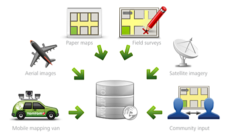
Figure 2
As shown above the company generated the data for TeleAtlas themselves using significant investment and man-hours in a diverse range of methods. This generated the basis for a wide selection of maps and services that the company offers on their site, of which a majority are pay-for-access only. TomTom specialise in simplifying travel for vehicles, which ranges from everyday use for the public to larger cliental who use the software and technology for shipping goods. This model works well for TomTom, as they rely on selling technology, such as SatNav’s, with their software pre-installed on devices. In contrast, TravelSafe is not intended to be installed on devices before they are to be bought, rendering this business model insufficient for our needs.
3.2 HappyPaths (Yahoo)
Yahoo’s new project, HappyPaths, is designed to build on the development of shortest route maps, as they believe routes with the option of highly extensive tailoring will be the future of the mapping market (Quercia et al., 2014). The goal of HappyPaths is to automatically suggest routes that are not only short but also emotionally pleasant. To achieve this they have used data from a crowd-sourced platform that shows street scenes in London (as the example city). A user then votes on which route looks more visually appealing, turning these votes into quantitative measures of locations in the network. The locations are then arranged on a graph which highlights the most visually pleasing routes.
Although this methodology places highest priority on route aesthetics rather than the shortest distance, Yahoo found that the recommended routes are only marginally longer than the shortest ones on average. This corresponds to similar study by Duckham and Kulik (2003), who discovered that placing the highest importance on path simplicity rather than shortest route produced routes that were on average only 10-16% longer than the shortest route available. This would be a valuable and applicable methodology for the Safest Route Generator for the TravelSafe app, and would allow for the aspect of Safety Rating to be the prioritised influencing factor in the route generations.
3.3 OpenStreetMap (Google)
Arguably Google are the dominant player when it comes to mapping in the modern age. Unlike a majority of the mapping market, Google’s OpenStreetMap is a collaborative project to create free editable maps in order to combat the dominance of closed, licenced or patented data and data processing (Haklay and Webber, 2008). It does not seek a profit, but does not however offer a tailored service for a specific target audience. Rather than the map itself, the data generated by the OpenStreetMap project is considered its primary output. This data is then available for use in both traditional applications, such as Craiglist, OsmAnd, Geocaching, MapQuest, Open JMP, and in uncommon uses such as to replace Google Maps, and to replace default data included with GPS receivers. For software in order to generate the Safest Route Maps, OpenStreetMap is the most viable solution to the problem of funding.
If the project were to use one of the two other options for mapping (either buying the research and information from an existing company or product, or investing large amounts of money and man-power into researching and building a network for oneself) we would severely impair the reach and commercialisation of app. By utilising open data and software the app would be virtually cost-free, and in a market where the majority of mapping apps are free this would be an extremely important aspect to the target audience.
4.0 Our Feature Proposal
Taking into account the literature and existing examples in the market, the TravelSafe Safest Route Generator is not only a plausible idea, but represents a transition from shortest-route mapping to the innovative trend of tailored routes and networked data. In order to keep the app free it will utilise OpenStreetMap software from Google, which will then be tailored using methods employed by Yahoo’s HappyPaths. The tailored routes will take into consideration safety rating as the highest priority, which will initially be generated from existing open data such as Direct.Gov.UK’s locational crime statistics. At the end of a route, a user will be prompted to answer the question ‘How safe did you feel while travelling along this route?’ answerable by a score out of 10. This data can then be anonymously collected, generating more accurate networks for the route generator to incorporate.
The Safest Route Generator will take into consideration ethical aspects regarding the use of the app, as it is possible that an individual may use the app to pinpoint locations where travellers are being directed, making it easier to commit a crime. Consequently, the generator will produce three possible routes for the user to take, making safety tips and warnings clear, such as ‘Do not always select the shortest route of the three calculated routes’. Further ethical aspects have been considered regarding the cost of the app, which will be free for use. Not only does this fit in with a majority of the mapping market, but also promotes good company and individual ethics which does not charge and individual for wanting to feel safe.
It is important to bear in mind that the platform specifications, clarifications of external data sets, and how user-generated data sets will update in real time are to be discussed in future posts, after further research.
5.0 The Networked Aspect
By encouraging a user to input data regarding the safety of a route, TravelSafe is incorporating a social networking solution to the problem of static and basic route generation in apps – this is something which no other mapping app on the market offers. Furthermore, the database generated by user input will form an intricate socially influenced network, allowing for a more complex and tailored route generation system that takes into consideration specific user needs. This will improve the nature of social network infrastructures in both travel and mapping apps in an innovative way, and encourage the shaping of technology by social need.
The generation of user input will develop aspects of trust associated with social media and human/computer networking, which is becoming an increasingly prominent feature of apps and websites (Gligor and Wing, 2011). The formation of user trust (also emotional trust, and similarities to yhprum’s law covered in the lecture materials) in knowledge transfer within the network of the app will cultivate a strong image of reliability, which studies argue is a necessity for the creation of viable and reliable knowledge, and the transfer of this (Levin and Cross, 2004).
In keeping with the findings of Duckham and Kulik (2003), user interaction will be in the simplest format thus warranting a larger number of participants. Once the generated data set regarding safety ratings has reached a reasonable size, the app may potentially offer a more in depth review process in a similar format to TripAdvisor in future developments. We anticipate the more in depth review process to be an aspect offered between 9 and 18 months after the launch of the app, as Kray (2003) suggests this is the optimal time for mobile-based apps to generate enough usability and social networking connections.
Written by Briony.
This post represents that the group has chosen appropriate economic and social Contextual Factors that directly link to the marking criteria, and are vital to understanding what requirements a specific app feature has. This is based on market analysis, evaluation, and expert opinions. There is evidence that questions that the app feature has been chosen intelligently (by reference to literature and analysis) to produce a conclusion of professional quality, leading to a successful product.
This post additionally represents Engineering and Design decisions. These are based on the Contextual Factors and literature review which the group have tailored the product to incorporate. This means that the app feature has considerable research, fluent design and well planned out engineering steps. All of which are apparent in this post, and are also illustrated with media. This app feature dictates future engineering steps, illustrates how and why the product has been influenced in its design, and shows how engineering this app feature will solve problems.
References
Bishop, C. M., Svensén, M., & Williams, C. K. (1998). GTM: The generative topographic mapping. Neural computation, 10(1), 215-234.
Duckham, M., & Kulik, L. (2003). “Simplest” Paths: Automated Route Selection for Navigation. In Spatial information theory. Foundations of geographic information science (pp. 169-185). Springer Berlin Heidelberg.
Finn, G. (1987). Routing and Addressing Problems in Large Metropolitan-Scale Internetworks. University of Southern California, ISI/RR-87-180.
Gilgor, V., Wing, J., (2011) Towards a Theory of Trust in Networks of Humans and Computers. 19th International Workshop on Security Protocols, Cambridge, UK
Haklay, M., & Weber, P. (2008). Openstreetmap: User-generated street maps.Pervasive Computing, IEEE, 7(4), 12-18.
HappyPaths (2014) [online] available at http://arxiv.org/abs/1407.1031
Jasika, N., Alispahic, N., Elma, A., Ilvana, K., Elma, L., & Nosovic, N. (2012, May). Dijkstra’s shortest path algorithm serial and parallel execution performance analysis. In MIPRO, 2012 Proceedings of the 35th International Convention (pp. 1811-1815). IEEE.
Kray, C., Elting, C., Laakso, K., & Coors, V. (2003, January). Presenting route instructions on mobile devices. In Proceedings of the 8th international conference on Intelligent user interfaces (pp. 117-124). ACM.
Levin, D. Z., & Cross, R. (2004). The strength of weak ties you can trust: The mediating role of trust in effective knowledge transfer. Management science,50(11), 1477-1490.
Pascalau, E. (2011). Towards TomTom like systems for the web: a novel architecture for browser-based mashups. In Proceedings of the 2nd International Workshop on Business intelligencE and the WEB (pp. 44-47). ACM.
Quercia, D., Schifanella, R., Aiello, L. (2014) Social and Information Networks (cs.SI). Computers and Society (cs.CY); Physics and Society
Sanders, P., Schultes. (2007) Engineering Fast Route Planning Algorithms. Universitat Karlsruhe, Germany.
TomTom satellite navigation company website (2014) [online] available at http://www.tomtom.com/en_gb/licensing/