Architectural Design

For our project we proposed 3 tier MVC architecture. The reason for proposing MVC is that gives data the ability to change independently and allows presentation of the same data in different ways (Pressman, 2010). With 3-layered architecture gives more secure accessing to data and authentication can be enabled in each layer (Sommerville, 2010). We believe that merging MVC with 3 Layered architecture gives more secure and enhance reuse functionality.

Architucture

References:

Sommerville, I. (2010) Software Engineering >INTERNATIONAL EDITION <. 9th edn. Harlow: Pearson Education (US)

Pressman (2000) Software Engineering: A Practitioner’s Approach (McGraw-Hill International Editions: Compute… 5th edn. United States: McGraw Hill Higher Education

Project Schedule-Gantt Chart

We made use of Gantt Chart to manage the requirements of the project. Besides we met weekly to assure the progress of the plan. Also, between the weekly meetings we used facebook group to communicate and support each other. Lastly, Google Drive was used for the tasks that was developed by more than one memeber of the team so that they can work on it in parallel. The reason of using the mentioned tools and techniques was the familiarity of the team with them. So that to work on the tasks immediately without wasting time to learn new tools to communicate.

Gantt Chart 2

Geosocial Networking

The advancement in geographical information system (GIS) made the geosocial networking born. Such networking is enriched by geographic services such as geo tagging and geo coding by using coordinates taking from global positioning system (GPS) technology (Ruiz Vicente et al., 2011).

Geo tagging is using geographic metadata to different media such as photo and video. Geo tagging technology is really useful because it gives the exact location of a friend who checked in on to a service. On the other hand, geo codding is the process of adding location information by geographic coordination to identify the addresses such post code or street name etc.

The Geosocial networking is matching users with their place such as (meeting groups, concerts, restaurants etc…) to socialize and facilitating meeting groups and plan activity. Also it gives the opportunity to meet others who are geographically closer and who have similar interests. It is also increase business ability to target more audience and find out what is near you is much easier

However, some times this type of technology leads to privacy invasion by disseminating too much personal information on the web. Pleaserobme.com is a website that criticize ironically to make people aware of oversharing.

geosocial
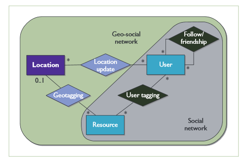
Geosocial Networking Concept (Ruiz Vicente et al., 2011)

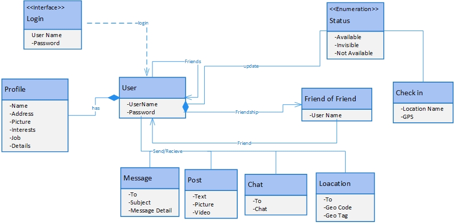
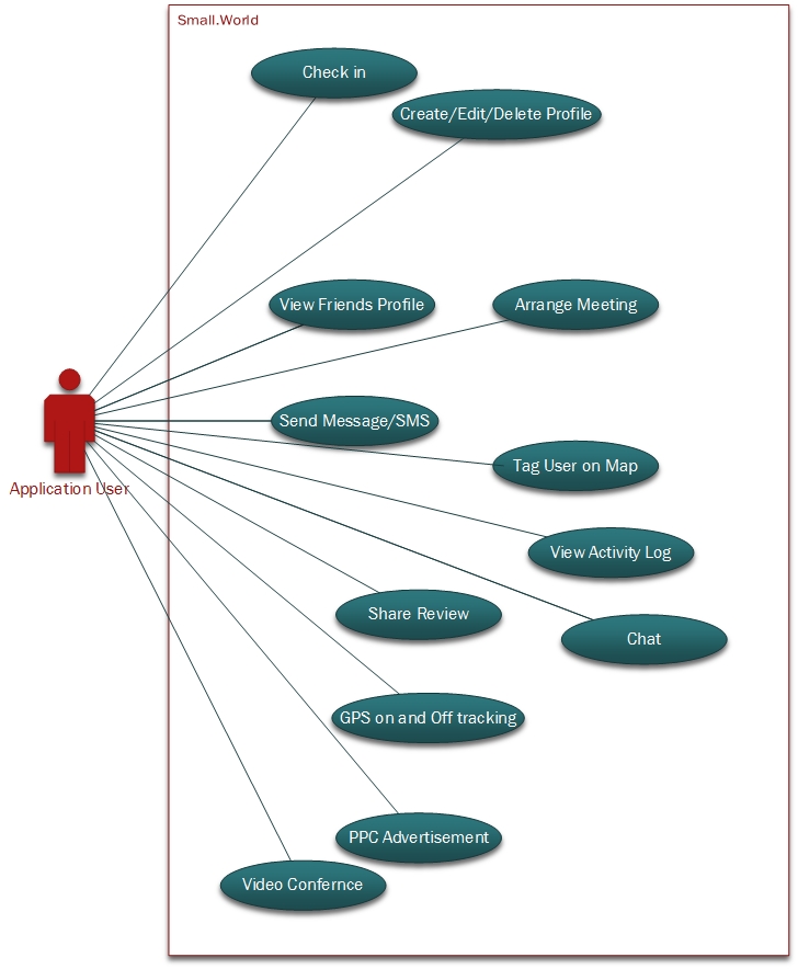
What is missing in the existing social networking now is building acommunity in real life. This can be achieved by Small.World through using geosocial networking and also enabling friends of friend to see your activities to broaden the network. Meeting people’s with the same interest in the around geographic location give you more options to make more friends in real life.


 Refrences 

Ruiz Vicente, C., Freni, D., Bettini, C. and Jensen, C. (2011). Location-Related Privacy in Geo-Social Networks. IEEE Internet Comput., 15(3), pp.20-27.


Class Diagram

The Class is the static structure of the system. The diagram illustrates the system classes, attributes, operations and interrelationship between them (Ambler, 2014). The class diagram is divided into two main sections, class name with blue background, attributes beginning with a minus sign (-) indicate a private attribute.The arrows show the associations between classes with labels indicating the nature of the relations. For example, User class is associated with Profile class, it means each user has it is own profile.For simplicity, only the main operations are included in these classes. As in requirements mentioned, the User class has Chat, Post, and Message class. To make the class diagram clearer and easily understood, some operations have been eliminated from the figure.


SmallWorld_Class Diagram1

Ethical Challenges Might Face Small.World

Small.World offers incredible large amount of real time data from its users. This might tend to face ethical issues that other social networking companies have been faced in the past.

So for this project the process of gaining ethical approval from ERGO (Ethics and Research Governance Online) of University Southampton will be considered.

The main ethical issues might Small.World encounters are but not limited to :

  • Who owns the data creates by Small.World?
  • GPS tracking
  • Misleading reviews
  • Cyber Bullying
  • Sharing negative sentiment about the business places such as restaurants and cafes
  • The amount of information that shared with FOAF.
  • Invasion of Privacy

Use Case Diagram for Small.World

This is the use case diagram for Small.World.

The Use case diagram below represents the main possible interactions of actors/stakeholders of Small.World. This is inline with the functional requiremnt of the application. The user first need to create account through multiple options such as google+, facebook or create account in Small.World. When the user login they can do different types of activity as shown in the diagram.
The Application, has many options that allows user to do videio conferencing, tag user on map and store past activity log, GPS tracking and pay per click advertisements are some of them.

*Visio Professional by microsoft is used to draw use case diagram because it has significant generralised drawing tools that allows you to produce any diagram very quickly. Asmallworld - Copy